About LasCruces-Weather.com
The original purpose of this station was to have accurate weather data available
for this area of town. This station is located approximately 20 bird-flying miles
and a river (Rio Grande) away from the Las Cruces International Airport that
provides the "official weather data" for Las Cruces, NM.
(See where we are)
There were too many "officially reported" sunny days for Las Cruces while I was getting pounded
with rain. Sadly, this area of the city doesn't have much "flood-control maintenance"
and while we can be watching our streets turn into rivers, the "official weather data"
can, historically, show virtually nothing. The rain data provided by LasCruces-Weather.com
might prove to be invaluable in future "discussions". Besides -
it's pretty cool to know exactly what the weather is in your own backyard...
Data has been collected by this station (also known as "EastMesaWeather.com") since April 3rd, 2007.
About The Station
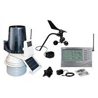
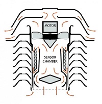
LasCruces-Weather is powered by a Davis Wireless Vantage Pro2 (#6153) weather station that uses a 24-Hour Fan Aspirated Radiation Shield . The station is comprised of an anemometer with windspeed and direction, rain gauge, temperature sensor, humidity sensor, barometer and solar radiation sensor. The FARS combines fan aspiration and passive shielding to minimize the effects of solar radiation - this results in more accurate temperature readings.
The web site and its data is primarily collected using Weather Display Software.
The data is collected every 2.5 seconds and the web site is updated every 10 seconds with current conditions.
The stats and graphs pages are updated every 5 minutes and the daily reports and summaries are updated shortly
after midnight (local time). Also utilized is WeatherLink & Cumulus software for data collection.
Weather software runs on a home-brew machine with an AMD FX-6300 & 16G of RAM on an ASUS M5A78L-M/USB3 mobo.
Sky cams are provided by 4 Olympus C4000Z, 1 Olympus C5000X and 1 Olympus C765 allcontrolled by VM95 software
running on 2 VMWare virtual machines running Windows XP Pro.
One runs on the Weather machine, the other on an AMD A8 5500 with 8G of RAM.
Printable Las Cruces, NM Weather Flier:
Free Printable Las Cruces, NM Weather FlierThe flier may be freely used by local hotels, motels, restaurants, businesses, and local government offices to pin on bulletin boards or distribute to their patrons.
Shared Weather Data
Station data is provided via direct Internet feed to the following weather networks (since):Weather Underground (04-23-07):
KNMLASCR14 (currently IDed as EastMesaWeather.com)
Las Cruces, NM (Cumulus software)
APRSWXNET/CWOP (12-28-07):
CW9386 (Weatherlink software)
Nearby CWOP
NOAA MesoMap (CW9386)
MesoWest (CW9386)
Rocky Mountain Weather Network (06-25-08):
RMWN (Weatherlink software)
There a few other organizations as well but I don't have the list at hand right now...
About This Website
This site is a template design by CarterLake.org with PHP conversion by Saratoga-Weather.org.
Special thanks go to Kevin Reed at TNET Weather for work on the original Carterlake templates, and his design for the common website PHP management.
Special thanks to Mike Challis of Long Beach WA for his wind-rose generator, Theme Switcher and CSS styling help with these templates.
Thermometer graphic courtesy of Bashewa Weather
(adapted from Saratoga Weather)
Cloud base graphic courtesy of Bashewa Weather
Special thanks go to Ken True of Saratoga-Weather.org for the AJAX conditions display, dashboard and integration of the TNET Weather common PHP site design for this site.
Template is originally based on Designs by Haran.